Docsity
Docsity

Prepare for your exams

Study with the several resources on Docsity


Earn points to download

Earn points by helping other students or get them with a premium plan


Guidelines and tips
Guidelines and tips

Exploring the Theory of Plate Tectonics: Evidence and Implications, Exams of Engineering

A worksheet example answer key for an activity aimed at gathering evidence to explain the theory of plate tectonics. Students are asked to explore various resources to understand continental drift, plate movements, and related phenomena such as earthquakes, volcanoes, and fossil records. The document also includes questions to guide students' analysis and reflection on the significance of plate tectonics for engineering and scientific understanding.

What you will learn

  • What evidence supports the theory of plate tectonics?
  • How have continents changed their positions over time?
  • How does the theory of plate tectonics relate to engineering?

Typology: Exams

2021/2022

Uploaded on 08/01/2022

hal_s95
hal_s95 🇵🇭

4.4

(652)

10K documents

1 / 3

Toggle sidebar

This page cannot be seen from the preview

Don't miss anything!

bg1
Name: ________________________________________________ Date: ______________________ Class: _________________
Earthquakes Living Lab: The Theory of Plate Tectonics ActivityWorksheet Example Answers 1
The Theory of Plate Tectonics Worksheet
Objective: Gather evidence to explain the theory of plate tectonics.
Materials: Work in pairs sharing one computer with Internet access.
Engage:
1. What continent do you live on? Can you think of any ways the continent has changed over time?
Answers will vary.
Explore: Navigate to the Earthquakes Living Lab at
http://www.teachengineering.org/livinglabs/earthquakes/.
Notice the four main components of the Earthquakes Living
Lab.
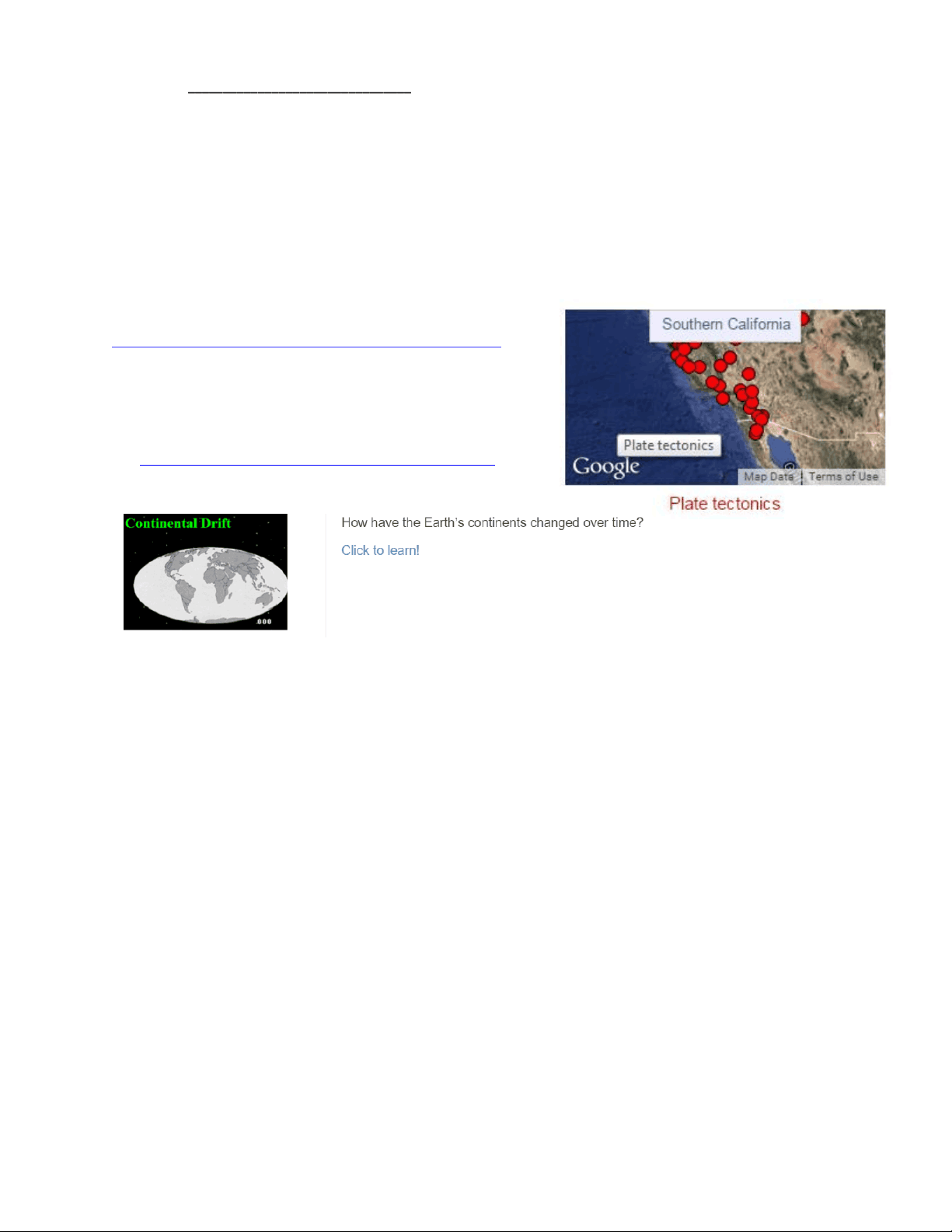
2. Select the second option, the “Southern California” box. >
click the third link on the right side of the page titled,
“How have the Earth’s continents changed over time?” at
http://www.ucmp.berkeley.edu/geology/anim1.html.
3. Compare the map of the world today (such as the real-time earthquake map) to a map of the world
250 million years ago (called Pangaea). Use the interactive continental drift map to watch the change
in the Earth’s landforms over millions of years.
As you watch the animation, record at least three examples of how the continents have changed
their positions over time.
Answers will vary. Expect students to describe how some landforms started as one mass and have
separated, or how other landmasses have moved to different locations.
If the plates continue to move in this pattern, draw a sketch of what the world might look like 250
million years in the future.
Sketches will vary. Grade sketches based on logic and completeness.
4. Explain: Navigate back to the Earthquakes Living Lab main page and click on the second and fourth
links titled, “What is the theory of plate tectonics? What evidence supports the theory of plate
tectonics?” and general information on plate tectonics. Explore more about the theory. Read the
background information and answer the following questions:
Example Answers
pf3

Partial preview of the text

Download Exploring the Theory of Plate Tectonics: Evidence and Implications and more Exams Engineering in PDF only on Docsity!

Name: ________________________________________________ Date: ______________________ Class: _________________

The Theory of Plate Tectonics Worksheet

Objective: Gather evidence to explain the theory of plate tectonics.

Materials: Work in pairs sharing one computer with Internet access.

Engage:

  1. What continent do you live on? Can you think of any ways the continent has changed over time?

Answers will vary.

Explore: Navigate to the Earthquakes Living Lab at http://www.teachengineering.org/livinglabs/earthquakes/. Notice the four main components of the Earthquakes Living Lab.

  1. Select the second option, the “Southern California” box. > click the third link on the right side of the page titled, “How have the Earth’s continents changed over time?” at http://www.ucmp.berkeley.edu/geology/anim1.html.
  2. Compare the map of the world today (such as the real-time earthquake map) to a map of the world 250 million years ago (called Pangaea). Use the interactive continental drift map to watch the change in the Earth’s landforms over millions of years.  As you watch the animation, record at least three examples of how the continents have changed their positions over time. Answers will vary. Expect students to describe how some landforms started as one mass and have separated, or how other landmasses have moved to different locations.

 If the plates continue to move in this pattern, draw a sketch of what the world might look like 250 million years in the future. Sketches will vary. Grade sketches based on logic and completeness.

  1. Explain: Navigate back to the Earthquakes Living Lab main page and click on the second and fourth links titled, “What is the theory of plate tectonics? What evidence supports the theory of plate tectonics?” and general information on plate tectonics. Explore more about the theory. Read the background information and answer the following questions:

Example Answers

Name: ________________________________________________ Date: ______________________ Class: _________________

  1. What might have caused the continents to move? (Hint: What is the name of this theory?)

Plate tectonics and their drifting

  1. Describe some important information related to this theory.

Answers will vary. Students may report information such as: Seven main plates (Eurasia, North America, Africa, South America, India, Australia and Antarctica) have diverged, converged or transformed over millions of years. Some coastlines are similar in shape and appear to “fit.” Unique fossil and rock similarities across ocean basins suggests continental movement shifting and drifting away from each other. The continuation and breaking of mountain chains, coral reefs and glacial deposits, as well as the locations of earthquakes and volcanic activity suggests the same. Additional ideas suggest why the plates move—perhaps due to convection currents and the Earth’s magnetism, as seen in the resulting ocean bases, trenches and ridges.

  1. Elaborate: Find and record evidence used to explain how continents have moved over time. Explore the following links to identify explanations and examples of evidence. You may also use any of the other links located on the Earthquakes Living Lab page. Use a graphic organizer (such as the chart below) to record your ideas.  Seafloor spreading and earthquakes: http://pubs.usgs.gov/gip/dynamic/developing.html  Fossils : http://aquarium.ucsd.edu/Education/Learning_Resources/Voyager_for_Kids/earth_puzzle/  Volcanoes: http://www.divediscover.whoi.edu/hottopics/seamounts.html

Category Evidence Examples and Explanations

sea floor spreading

 Fred Vines’ Atlantic mid-ocean ridge symmetrical magnetic stripes  Age-dating sediments on either side of a ridge indicate the sediments get progressively older away from the mid-ocean ridge axis  Thickness of sediments also increases away from the ridge

fossils

 Fossil similarities: mesosaurus fossil, between Africa and South America  Identical plant fossils found on several continents  Dinosaur fossils found cross-continental  Rocks of same age found across ocean basins

earthquakes

 Earthquakes occur along plate margins, ocean trenches and spreading regions  “Wadati-Benioff Zones” are identified as prominent earthquake zones  Pervasive seismic mapping of the earthquake concentration zones worldwide